Drone Real Estate Photography Guide: What Agents Need in 2026
A drone is the difference between "here's the house" and "here's the property" — and for some listings that's the whole pitch. This guide covers when aerial real estate photography is worth the time and certification, the FAA rules that actually matter in 2026, and how AI enhancement turns a cloudy-day drone flight into a sunny-day listing.
Not every listing needs drone shots. A 1,200-square-foot downtown condo isn't going to sell better because you flew over the roof. But a five-acre lot, a luxury exterior, an ocean view, a complicated roofline, or anything where context matters — that's where drones pay for themselves on the first listing.
The good news: the barrier to entry is the lowest it's ever been. A capable drone now costs less than a good lens. The FAA Part 107 certification takes about two weeks of evenings and $175. And modern AI enhancement fixes the problems drone shots tend to have — gray skies, flat colors, distracting clutter on lawns — in seconds instead of the hours it used to take in Photoshop.
When Drone Photography Is Actually Worth It
The clearest use cases, in order of how much value a drone adds:
- Acreage and rural listings. A 10-acre horse property is impossible to frame from the ground. An aerial shot tells the whole story in one image.
- Waterfront and view properties. Ground-level shots can suggest a view. Aerial shots prove it.
- Luxury exteriors. At the higher end of the market, buyers expect aerial photography. Showing up without it looks underprepared. More on this in our luxury real estate photography guide.
- Complicated rooflines and architecture. A butterfly roof or a wrapping deck reads cleanly from above and confusingly from the ground.
- Neighborhood context. Proximity to a park, a beach, a downtown — things that drive price per square foot — are best shown from altitude.
Where drones usually aren't worth it:
- Condos and townhomes. You can't fly inside; exteriors from the ground are usually enough.
- Small urban lots. The FAA's line-of-sight and crowd rules make flights in dense neighborhoods a hassle, and the payoff is a photo of a roof.
- Listings priced under the market median for the area. The extra $150-400 for a drone shoot is a meaningful percentage of the marketing budget, and buyers in that segment respond more to interior shots.
If you're an agent in any of the "worth it" categories more than twice a year, getting certified yourself or finding a reliable certified contractor is the better long-term play than hiring ad-hoc.
FAA Part 107: What You Actually Need in 2026
Anyone flying a drone for compensation in the US needs a Part 107 Remote Pilot Certificate. That includes shooting listing photos for a brokerage you work for, not just freelance photography jobs. There's no "hobbyist loophole" for commercial listings.
The 2026 rules that actually matter:
- Part 107 certificate: Passed a 60-question knowledge exam at an FAA-approved testing center. $175. Valid for 24 months, then a free online recurrent training to renew.
- Drone registration: Required for any drone over 0.55 lbs. $5 per aircraft, valid three years.
- Remote ID: Now fully required. Your drone must broadcast its identity and location in flight. Every DJI drone sold since 2022 supports this out of the box; older drones need a bolt-on module.
- LAANC authorization: For flights in controlled airspace (near any major airport, basically), you need Low Altitude Authorization and Notification Capability approval. Apps like Aloft and Airspace Link handle the request in real time, usually granted in seconds.
- Visual line of sight: You — or a designated visual observer — must maintain visual contact with the drone throughout the flight. BVLOS (beyond visual line of sight) is available with an additional waiver in 2026 but rarely worth the paperwork for listing work.
Weight and altitude limits to know: max 400 feet above ground level (or 400 feet above the tallest structure within 400 feet horizontally), max 100 mph ground speed, and the drone must remain under 55 pounds. None of these constrain real estate flights in practice.
International Quick Notes
If you're shooting outside the US: Canada requires a Basic or Advanced RPC for drones over 250g. The EU uses a tiered Open/Specific/Certified category system. The UAE requires GCAA approval for commercial flights. Australia uses ReOC licensing for commercial operators. Check the local authority before you travel with a drone — enforcement is uneven but fines are real.
Pro Tip
Keep a digital copy of your Part 107 certificate on your phone. You're required to produce it on request from law enforcement or an FAA inspector, and yes, people do get checked on busy shoots. A PDF on your camera roll satisfies the requirement.
Gear: What to Buy, What to Skip
Most real estate agents are genuinely well-served by a sub-$1,000 drone. Professional drone photographers can justify more. The sweet spot has changed a lot since 2023.
Drones Worth Buying in 2026
- DJI Mini 4 Pro (~$759): Under the 250g Remote ID bolt-on threshold in some jurisdictions, 4K/60fps, obstacle sensing in every direction. Best agent-grade option.
- DJI Air 3S (~$1,099): Dual camera (wide + medium telephoto), which is genuinely useful for pulling in landscape detail without physically flying further from the property.
- DJI Mavic 3 Pro (~$1,999): Triple camera including a 70mm equivalent, 4/3 sensor, 46-minute flight time. Professional drone photographer territory.
- Autel EVO Lite+ (~$1,000): The non-DJI option that matters. 1-inch sensor, 6K video, stronger US manufacturing narrative if that's a concern for your brokerage.
Skip: sub-$300 generic drones (battery life and image quality aren't there), anything that can't broadcast Remote ID out of the box, and "racing" drones that don't have a gimbal.
Must-Have Accessories
- Three batteries minimum: A listing shoot burns through one battery per 20-25 minutes. Two is tight. Three gives you room to reshoot.
- ND filters: Neutral density filters let you use slower shutter speeds for smoother video. A six-stop ND is the one you'll reach for most.
- A sturdy hard case: The foam-lined case the drone ships in is fine for storage. Anything that rides in the back of your car needs a harder case.
- Fast microSD cards: V30 speed class minimum for 4K video. Slower cards drop frames.
For a broader gear breakdown that includes ground-level cameras and lenses, see our real estate photography equipment guide.
The Shot List for a Standard Listing
For a typical residential drone shoot, aim for 6-10 keepers in this order:
- High establishing shot (200-250 ft): Full property in frame with significant neighborhood context. The "here's where it is" photo.
- Mid-altitude hero (100-150 ft): The headline aerial. Property centered, rooflines visible, landscaping readable. This is the MLS thumbnail.
- Front-facade angle (60-80 ft): Lower, closer, angled from the street side. Shows curb appeal with some aerial depth.
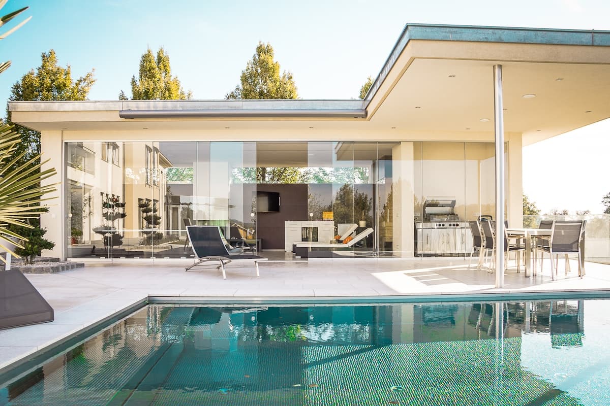
- Backyard/pool shot (50-100 ft): Features the outdoor living space — pool, deck, kitchen, firepit.
- Side-profile passes: Two shots from each side at 80-120 ft, showing depth of the lot and side setbacks.
- Roof shots (80-100 ft): Straight down or near-down. Useful for buyers checking roof condition on older homes.
- Neighborhood context (150-200 ft, facing away from the house): Shows the view from the property — ocean, park, downtown skyline, whatever the selling point is.
For video, add:
- Reveal pull-back: Start close on a feature (front door, pool), fly back and up to full establishing view.
- Orbit: A slow circle around the property at a fixed altitude and distance.
- Pass-over: A low forward pass over the house, rising as you clear the far roofline.
Three clips, 8-15 seconds each, is plenty for a social cut.
Lighting and Timing
Aerial photography lives and dies by sun angle. The rules are simpler than ground-level photography.
- Best light: One hour after sunrise, one hour before sunset. Warm, directional, flattering on landscaping and architecture.
- Acceptable light: Full overcast during mid-day. Flat and soft. Often better than harsh noon sun for residential exteriors.
- Hardest light: Clear noon sun. Every texture in the roof is a hot highlight and every tree throws a hard shadow. Avoid if possible.
- Bad idea: Wind over 20 mph (gimbal fights the drone), rain of any kind (most drones aren't weather-sealed), or temperatures below 32°F (battery life drops sharply).
If you're stuck with overcast skies, the fix is AI sky replacement — covered in the next section.
Pro Tip
Check the wind forecast at the altitude you'll actually fly, not ground level. Apps like UAV Forecast give you wind speed at 100, 200, and 400 feet. The ground can feel still while 200 feet up is gusting 25 mph — and that's the altitude your drone will be operating at.
AI Enhancement for Drone Shots
Aerial photos have three common problems and AI enhancement fixes all three reliably.
Gray Sky? Replace It
The single biggest aerial-photo issue is an overcast sky washing out the top half of the frame. PropertyPixel's blue-sky replacement detects the sky region, swaps it for a clean blue with realistic cloud detail, and matches the lighting on the rest of the image so it looks natural. What used to be a two-hour Photoshop masking job is about 30 seconds.
This isn't cosmetic — MLS listings with gray skies get measurably fewer clicks than listings with clean blue skies on the hero shot. The cost of a reshoot is far higher than the cost of an AI sky swap.
Twilight Exteriors Without Twilight
Actual twilight drone flights are legal but narrow: you have a 20-minute window of usable light after sunset, the FAA requires anti-collision lighting on the drone for civil twilight operations, and if you miss the light you reshoot tomorrow.
The alternative is shooting during the day and using day-to-dusk AI conversion on the final image. The model converts a daytime exterior into a warm twilight shot with interior window lights glowing. For luxury and high-end listings, this produces the "single best-performing exterior shot type" without locking you into a 20-minute sunset window.
Lawn Repair and Distraction Removal
Brown patches, construction materials next door, a neighbor's trampoline, a trash bin at the curb — aerial shots show everything, including the stuff you don't want. Purpose-built fixes like lawn repair handle the first problem, and general object-removal handles the second.
What AI Can't Do For Aerial Shots
Brand honesty matters more here than on ground-level shots, because aerial photos go further before they're judged.
- AI cannot fix motion blur from a gusty flight. If the gimbal couldn't stabilize, no sharpening algorithm will save the frame. Reshoot.
- AI cannot invent terrain that wasn't captured. If half the lot is cut off by the frame, it stays cut off. The model doesn't know what the grass behind the fence looks like.
- AI struggles with very complex sky/foliage edges. Sky replacement on a shot with intricate tree branches against the sky can produce soft or uneven edges. Usually imperceptible at MLS size, sometimes visible if blown up for print.
- AI cannot rescue a composition that's fundamentally off. If the property is small in the frame or tilted on the horizon, crop and level in post — but if it's really wrong, reflying is faster than fighting the edit.
What It Costs (DIY vs. Hiring)
The rough 2026 numbers most agents see:
- Hiring a Part 107-certified drone photographer: $150-350 for a standard residential shoot (6-10 photos, optional short video). $500-1,200 for luxury properties with video and more flight time.
- Buying your own drone + certification: $760 for a DJI Mini 4 Pro, $175 for the Part 107 exam, $50-100 for test-prep material, plus 15-20 hours of study time. Break-even is about 4-6 self-shot listings.
- Post-production: $10-25 per image for traditional retouching, or a credit-based AI enhancement subscription that runs a fraction of that per photo. See PropertyPixel pricing for current rates.
If you're doing more than four drone-suitable listings a year, owning the drone and doing the shoots yourself is the better economic call — assuming you enjoy the process. Some agents don't. Hiring a reliable local contractor and focusing on your listing presentations is a perfectly reasonable choice.
For any of these options, AI post-production changes the math. The photographer you hire delivers faster. The shoots you DIY don't sit in an editing queue. The cost per enhanced photo drops to something close to the sensor-wear cost of taking the shot in the first place.
The Mistakes That Waste Flights
A short list of the ones that cost real time:
- Shooting only mid-altitude: A shoot with no high establishing shot and no low-detail shot is a one-note deliverable. Vary altitude deliberately.
- Ignoring the gimbal horizon: Most drones auto-level, but on a windy day the gimbal occasionally drifts. Check every shot before you pack up.
- Forgetting to bracket exteriors: High-contrast aerial scenes (bright sky, shadowed front facade) benefit from a 3-bracket even more than interiors do. Modern drones have AEB built in.
- Flying without a backup plan: Weather rolls in, a battery fails, a neighbor complains. Build 30 minutes of buffer into every shoot.
- Skipping the post-flight review: Check the memory card on a phone or laptop before you leave the property. Reshoots are cheap when you're still on site.
The Bottom Line
Aerial photography is a force multiplier on the right listing and a waste of time on the wrong one. Match the tool to the property: acreage, luxury, waterfront, complex architecture, and neighborhood-context listings genuinely need it. Downtown condos and median-priced suburban tract homes usually don't.
When you do fly, shoot for the specific shot list above, pick the right time of day, and plan on running the batch through AI enhancement for sky replacement, color correction, and lawn repair. That combination produces magazine-quality aerial deliverables at a speed that makes regular drone photography actually sustainable for a working agent.
Turn Gray-Sky Drone Shots Into Sunny-Day Listings
Upload your aerial batch and get clean blue skies, corrected color, and twilight conversions in minutes. Free trial credits, no card required.
Continue Reading
Real Estate Photography Equipment Guide 2026
Complete gear breakdown for every budget — from entry-level to professional setups
Read articleLuxury Real Estate Photography Guide 2026
High-end listing photography techniques that match buyer expectations at the top of the market
Read article3D Virtual Tours vs Video Walkthroughs: Which Drives More Sales?
Compare immersive viewing technologies to choose the right tool for each listing
Read articleEnhance Your Listing Photos Today
Transform your property photos with AI-powered enhancement — try PropertyPixel free with your first 3 images